 large (for the East Coast) hills lining both sides of the Hudson river near Peekskill, New York. There were first discovered by Europeans when Henry Hudson and his crew sailed up the river in the early 1600's.
The trail I took, which is really an amalgamation of several interconnecting trails, begins in a small parking area across the street from Little Stony Point Bridge. I was pretty excited when I arrived, and hurriedly scarfed the sandwich I brought while I packed up my packed and retied my boots.  The first section of trail was rather steep, and though my enthusiasm was not reduced my speed most certainly was. The trail rises about 600 feet in the first half mile, and it plateaus at a rather large quarry seemingly blasted into the hillside. The trail continues off to the left through a number of pines and over a bunch of boulders, gradually getting even steeper, eventually bringing you to a series of overlooks around 1,000 feet above the parking lot.
 The first section of trail was rather steep, and though my enthusiasm was not reduced my speed most certainly was. The trail rises about 600 feet in the first half mile, and it plateaus at a rather large quarry seemingly blasted into the hillside. The trail continues off to the left through a number of pines and over a bunch of boulders, gradually getting even steeper, eventually bringing you to a series of overlooks around 1,000 feet above the parking lot.
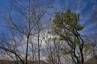
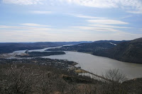
You can stare off to the south over the Hudson for a long time and not get tired of the view, and with the gorgeous blue sky  this afternoon was particularly spectacular. The best views are most likely had farther up from the summit of Mt. Taurus, but I did not get up there as I saw some storm clouds and wanted to move on before I got caught in the rain. It didn't rain and in fact ended up as a beautiful day, but I am glad not to have climbed Taurus as I it gives me something to go back for.
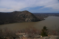
I continued along the ridge, taking gorgeous pictures of Storm King (right) and the nortern Hudson until my camera ran out of batteries and I reluctantly had to put it away. The hike continued down a steep hill, across a stream and then up a steep, badly marked series of trails that brings you to the top of Breakneck ridge. On the way up I saw some incredible icicles clinging stubbornly to a fallen branch as the sun eased them away, and I in desperation I tried my dead camera, and low and behold, it worked for about 10 more minutes before conking out completely. At that point I was well along the ridge, about 1,100 feet up, staring out over
  the entire expanse of the lower Hudson valley. It was spectacular ...
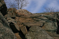
I continued across the ridge, rather exhausted from the strenuous climb (the trail I was hiking is on the left, it really is up over those rocks following that small swatch of white) .... how is that I always pick the tough hikes to do when I am out of shape and just getting back into the hiking season. So after the 4th rise, the trail moved quickly down from the ridge and past some ruins. Apparently, some settlers from Cornwall (I think) once had a large dairy here, by the small lake just east of the Hudson, and its ruins still feature prominently along the trail. Past the ruins the trail is pretty much a straight shot out, veering south after a little and paralleling the highway until it reaches the parking lot about .5 miles ahead.
All in all a great hike, I highly recommend it ... wish my camera hadn't pooped out .. but since I didn't get to Mount Taurus I will have to go back :)
To get to this hike drive north from the Bronx to Peekskill, drive through the center of town and look for a small parking area across from little stony point bridge. The trail is fairly easy to follow, although I would recommend some sort of map or guidebook (the trail is on Trails.com) to allow you to follow the many changes in the colors of the trail signs.
 this afternoon was particularly spectacular. The best views are most likely had farther up from the summit of Mt. Taurus, but I did not get up there as I saw some storm clouds and wanted to move on before I got caught in the rain. It didn't rain and in fact ended up as a beautiful day, but I am glad not to have climbed Taurus as I it gives me something to go back for.
I continued along the ridge, taking gorgeous pictures of Storm King (right) and the nortern Hudson until my camera ran out of batteries and I reluctantly had to put it away. The hike continued down a steep hill,
 across a stream and then up a steep, badly marked series of trails that brings you to the top of Breakneck ridge. On the way up I saw some incredible icicles clinging stubbornly to a fallen branch as the sun eased them away, and I in desperation I tried my dead camera, and low and behold, it worked for about 10 more minutes before conking out completely. At that point I was well along the ridge, about 1,100 feet up, staring out over
  the entire expanse of the lower Hudson valley. It was spectacular ...
I continued across the ridge, rather exhausted from the strenuous climb (the trail I was hiking is on the left, it really is up over those rocks following that small swatch of white) .... how is that I always pick the tough hikes to do when I am out of shape and just getting back into the hiking season. So after the 4th rise, the trail moved quickly down from the ridge
 and past some ruins. Apparently, some settlers from Cornwall (I think) once had a large dairy here, by the small lake just east of the Hudson, and its ruins still feature prominently along the trail. Past the ruins the trail is pretty much a straight shot out, veering south after a little and paralleling the highway until it reaches the parking lot about .5 miles ahead.
All in all a great hike, I highly recommend it ... wish my camera hadn't pooped out .. but since I didn't get to Mount Taurus I will have to go back :)
To get to this hike drive north from the Bronx to Peekskill, drive through the center of town and look for a small parking area across from little stony point bridge. The trail is fairly easy to follow, although I would recommend some sort of map or guidebook (the trail is on Trails.com) to allow you to follow the many changes in the colors of the trail signs.

No comments:
Post a Comment